

Saser Kangri, the highest summit of the Saser Muztagh and the easternmost crown of the Karakoram Range, stands as one of the world’s most captivating mountain destinations for adventure, culture, and nature lovers.
Location and Elevation
It stands majestically in Ladakh, India, rising to 7,672 metres (25,171 feet), making it the 35th highest mountain in the world and the highest peak in the Saser Muztagh subrange of the Karakoram. Its coordinates are 34°51′54″N 77°45′09″E, with the massif forming a distinctive “yellow peak” due to its golden rock formations, reflected in its Tibetan name.
Key Details:
Note: Costs can vary widely based on trek group size, services, and season. These expeditions require excellent fitness, acclimatisation, and detailed logistical planning, and are only recommended for advanced and expert trekkers/mountaineers.
History and First Ascents
- The mountain’s allure drew Indian expeditions as early as the 1950s, with the first successful summit of Saser Kangri I recorded in 1973 by the Indo-Tibetan Border Police, which led the expedition through the Shyok Valley and the North Shukpa Kunchang Glacier.
- Subsequent expeditions continued the tradition of discovery: Saser Kangri II West was first scaled by an Indo-Japanese team in 1984; Saser Kangri II East, initially famous as the highest unclimbed peak where climbing was permitted, saw its first ascent in 2011 by American climbers Mark Richey, Steve Swenson, and Freddie Wilkinson.
- Saser Kangri III was first conquered in 1986 by an Indo-Tibetan Border Police team, overcoming the crevasses, dangerous cornices, and harsh climatic challenges that define the region.
- These historic climbs solidify the mountain’s reputation as a technically demanding and prestigious objective in mountaineering.
Geographical and Geological Characteristics
- The Saser Kangri massif includes six named peaks: PeakHeight (meters)Rank WorldwideSaser Kangri I7,67235thSaser Kangri II E7,51849thSaser Kangri II W7,500-Saser Kangri III7,49551stSaser Kangri IV7,416-Plateau Peak7,287
- The massif lies towards the northwest end of the Saser Muztagh, abutting major glaciers (Shukpa Kunchang, Sakang, and Pukpoche), which feed the Nubra River, a vital source for downstream ecosystems.
- Composed mostly of granite and metamorphic rock, the Karakoram range and its broader surroundings are a direct result of the tectonic collision between the Indian and Eurasian plates, resulting in their steep, rugged slopes and extensive glacial terrain.
Climate and Environmental Significance
- Its high elevation subjects climbers and wildlife to extreme cold, heavy snowfall, violent storms, and unpredictable weather. This cold desert climate shapes the local ecology and trekking realities.
- The glaciers provide year-round water to the region, making the massif an environmental asset for Ladakh.
- Flora includes hardy alpine and subalpine shrubs, grasses, and rare medicinal herbs, while fauna includes Himalayan birds, marmots, and snow leopards, all of which are adapted to high-altitude conditions.
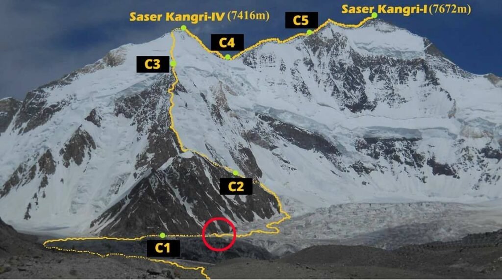
Trekking and Mountaineering
Routes and Adventure:
- It summit is one of India’s most demanding climbs, requiring advanced mountaineering skills, technical equipment, and acclimatisation.
- Popular approaches begin in the Nubra Valley, often following the Chameshan Lungpa Valley and the Sakang Lungpa or North Shukpa Kunchang Glaciers, with camps at various altitudes before reaching the peak.
- A trek to Saser La Pass offers panoramic views of the Karakoram’s splendour, traversing remote valleys, glaciers, and connecting with trails such as the Shyok Valley and Siachen Glacier.
Planning a Trek:
- The best months for trekking or attempting a summit are July, August, and September, when conditions are comparatively stable.
- Expeditions must be meticulously planned, with permits from Indian authorities (exclusive foreign teams are restricted), and strict adherence to environmental regulations and respect for local customs.
Tourist Attractions and Experiences
- Its status as a remote and “unspoiled” jewel draws international mountaineers, environmental scientists, and cultural explorers.
- The Nubra and Shyok Rivers, fed by the massif’s glaciers, anchor local communities and invite travellers to glimpse Ladakh’s unique wildlife and lifestyles.
- Adventure tourism is growing, with the region recently hosting high-altitude competitions and Indian Army-led expeditions to inspire visitation and international attention.
Local Culture and Heritage
- Ladakh’s people hold its high-altitude landscapes and the surrounding mountains with deep spiritual reverence, as the mountains are woven into local folklore and Tibetan Buddhist traditions.
- The name “Saser Kangri”, meaning “Yellow Snow Peak”, highlights the intersection of natural beauty and local language.
- Trekkers are invited to experience the vibrant villages, prayer flags, and monasteries along their journey, connecting with both a living culture and the timeless silence of the Himalayas.
Saser Kangri: Recent Developments
As of 2025, Ladakh’s high-altitude Karakoram peaks, including those in the region, are gaining momentum as premier adventure destinations. Recent Army expeditions and growing tourism initiatives aim to honour historical legacies and stimulate sustainable mountaineering and trekking activity in this region. Conservation measures, community engagement, and international events stand poised to shape the future of the Ladakhi landscape and its broader context.
Saser Kangri in India’s 2025 Mountaineering Spotlight
Ladakh’s Saser Kangri continues to garner global recognition in 2025, with high-altitude expeditions highlighting India’s northern frontiers as spaces for adventure, remembrance, and environmental stewardship. In May, elite Army mountaineers commemorated Galwan heroes by scaling neighbouring Karakoram summits, a symbolic ascent that fused history with the promise of international mountaineering competitions. Tourism authorities and local stakeholders actively promote its potential, striking a balance between sustainable trekking and conservation, while respecting the delicate ecosystems of Ladakh. As adventure seekers from around the world prepare to experience its wild beauty, it remains Ladakh’s living emblem, where past achievements meet the promise of the future, in the sweeping solitude of the Karakoram.
FAQs About Saser Kangri
Where is Saser Kangri located?
It is in the Ladakh region of northern India, forming part of the eastern Karakoram Range.
How tall is Saser Kangri I?
Saser Kangri I rises to 7,672 meters (25,171 feet), making it the 35th highest peak worldwide.
When was the first time I climbed Saser Kangri?
The first successful ascent of Saser Kangri I was in 1973 by the Indo-Tibetan Border Police.
What does ‘Saser Kangri’ mean?
In Tibetan, “Saser Kangri” translates to “Yellow Peak” or “Yellow Snow Peak,” referencing its golden rocks.
What trekking routes are popular?
Popular trekking routes include the ascent to Saser Kangri, the Saser La Pass, and glacier traverses such as the Shyok Valley and Siachen Glacier trails.
Why is Saser Kangri important for Ladakh?
The massif provides vital glacial water to the region, supports rare flora and fauna, offers adventure tourism opportunities, and holds cultural significance for local people.
What permits are required for Saser Kangri?
Indian authorities mandate joint expeditions; foreign-only teams are not permitted to participate. Climbers must apply for guidance and permits from the Indian Mountaineering Foundation.
What are Saser Kangri’s main climatic challenges?
Extreme cold, unpredictable storms, avalanches, crevasses, and thin air make climbing and trekking highly challenging.
What flora and fauna exist around Saser Kangri?
Alpine and sub-alpine plants, rare medicinal herbs, and Himalayan wildlife, such as marmots and snow leopards, are found, adapting to high-altitude, cold desert conditions.
How many named peaks are in the massif?
There are six main peaks: Saser Kangri I, Saser Kangri II East, Saser Kangri II West, Saser Kangri III, Saser Kangri IV, and Plateau Peak.