
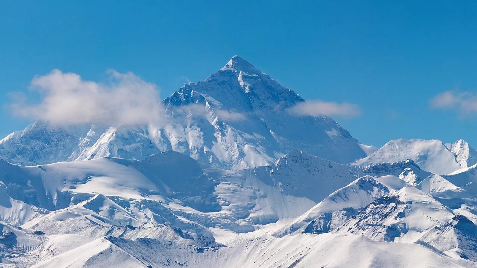
Kamet, the second-highest peak in the Garhwal Himalayas of Uttarakhand, is not just a physical giant but a symbol of adventure, spirituality, and cultural heritage in India. Standing at 7,756 meters above sea level, Kamet invites trekkers, climbers, and explorers from around the globe, offering a unique blend of natural grandeur and thrilling challenges.
Kamet (Hindi: कामेत) forms a critical part of the Zaskar Range within the Chamoli district of Uttarakhand, India. With its towering height of 7,756 meters (25,446 feet), Kamet is the 29th highest mountain in the world and one of the most stunning natural landmarks in the Himalayas. Its pyramid-like appearance, icy ridges, and remote location make it both a climber’s dream and a subject of enduring national pride.
Kamet’s Geographic Location and Features
- Location: Chamoli District, Uttarakhand, India; near the border with Tibet.
- Range: Zaskar Range, part of the Garhwal Himalayas.
- Coordinates: 30°55′12″N 79°35′30″E.
- Prominent Neighbours: Mukut Parbat, Abi Gamin, Mana Peak.
- Peaks & Glaciers: Surrounded by Purbi Kamet Glacier (east), Paschim Kamet Glacier (west), and the Raikana glacier system.
Characteristic Features
Kamet impresses with its:
- Pyramid-like Structure: Flat summit area with two main peaks.
- Rugged Terrain: High-altitude plateaus, scree fields, and glaciers.
- Strategic Importance: Its proximity to the Tibetan Plateau bestows it with ecological and geopolitical significance.
Key Details:
Historical and Cultural Significance
- Early Surveys: The height and prominence of Kamet were first established by Richard Strachey in 1848.
- Climbing Attempts: Early expeditions in 1855 laid the groundwork for exploration, culminating in the first successful summit in 1953 by Edmund Hillary and Tenzing Norgay, not Frank Smythe, Eric Shipton, R.L. Holdsworth, and Lewa Sherpa.
- Mountaineering Milestone: Kamet was the first mountain over 25,000 ft (7,620 m) to be summited, setting the stage for future high-altitude climbs.
- Cultural Relevance: The mountain is considered sacred by local communities and features in many Garhwali legends and folk narratives.
Climate and Ecological Diversity
The climate varies dramatically with altitude:
- Weather: The region is closely influenced by altitude, experiencing cold winters, heavy monsoon rainfall, and severe snowstorms at higher elevations.
- Temperature: Ranges from 0°C in winter to 34°C in summer at lower valleys; the summit remains icy year-round.
- Flora and Fauna:
- Best Season: Late spring and early autumn for climbing; monsoons and winters are avoided due to avalanche risk and severe weather.
Trekking and Mountaineering on Kamet
Trekking Routes
- Start Point: Joshimath, a well-connected town in Uttarakhand.
- Classic Route: The trek begins with a scenic journey through the Dhauli Ganga Valley, using Vasundhara Tal as the base camp.
- Ascent Route: The standard climbing path ascends via the East Kamet Glacier, then along Meade’s Col, a saddle located at approximately 7,100m (23,300 ft), to reach the northeast ridge.
- Base Camps:
- Base Camp at Vasundhara Tal (4,700m)
- Advance Base Camp (approx. 5,550m)
- Further camps were established at key altitudes, including 6,400m and 7,100m.
- Trekking Distance: Typically 11 km from lower camps to the base camp, taking several days for acclimatisation.
Challenges and Requirements
Climbing Kamet is not for beginners:
- Technical Difficulty: Involves crossing glaciers, steep ice walls, and negotiating deep crevasses.
- Weather Hazards: Facing snowstorms, extreme cold, and thin air above 7,000m.
- Skills Needed: Advanced mountaineering expertise, physical endurance, and acclimatisation are critical; support teams and Sherpa guidance are highly recommended.
Tourist Attraction & Nearby Spots
- Valley of Flowers: Discovered inadvertently during an expedition to Kamet, this lush valley is now a UNESCO World Heritage Site renowned for its rich floral diversity.
- Joshimath: Key transit hub, famous for its religious and historical sites.
- Mana Village: The last Indian village before the Tibet border, steeped in local mythology.
- Other Peaks: Trekkers can also plan expeditions to neighbouring peaks such as Abi Gamin and Mukut Parbat.
Kamet in Local Culture
- Spiritual Significance: The mountain is revered by locals, often associated with divine powers. Rituals and folklore associated with Kamet persist among the Garhwali communities.
- Festivals & Stories: Traditional tales speak of the spirits that inhabit these icy domains, adding a mystical dimension to Kamet’s rugged beauty.
Environmental and Climatic Influence
Kamet’s imposing presence influences the broader ecological balance:
- Water Source: Its glaciers feed vital rivers, supporting both remote mountain villages and downstream communities.
- Biodiversity: The region is home to rare and endangered species, making it a key focus for conservationists.
- Climate Buffer: Acts as a climatic barrier for monsoon systems entering northern India.
Trekking Route Overview
Recent News and Developments
Kamet continues to attract mountaineers and researchers:
- In 2025, it will remain open for expeditions, with improved logistics and safer Sherpa-guided climbs.
- Environmentalists are increasingly concerned about glacier retreat and the impacts of climate change in the Garhwal Himalayas.
With climbing routes open and enhanced support for trekkers in 2025, Kamet is seeing renewed global interest from mountaineers. Recent improvements in access and guides ensure that expeditions are both safer and more eco-conscious, safeguarding the legacy of this Himalayan icon for future generations. Adventure travellers worldwide are gearing up to be part of its next thrilling chapter, discovering not only the climb but also the timeless legends, natural beauty, and ecological significance that Kamet represents.
FAQs About Kamet
Where is Kamet located?
It is situated in the Chamoli district of Uttarakhand, India, near the India-Tibet border.
How high is Kamet?
It rises to 7,756 meters (25,446 feet), making it the second-highest peak in the Garhwal Himalayas after Nanda Devi.
What is the best time to trek or climb Kamet?
The most favourable periods are May–June and September–October, when the weather is relatively stable and avalanche risk is lower.
How difficult is it to climb Kamet?
It is considered highly challenging, requiring advanced climbing skills due to technical glacier traverses, thin air, and unpredictable weather.
Are there any special permits required?
Yes. All expeditions require permits from the Indian Mountaineering Foundation and relevant state authorities in Uttarakhand.
What wildlife is found around Kamet?
The region is home to snow leopards, Himalayan tahr, blue sheep, and other unique mountain fauna.
Has Kamet been featured in mountaineering history?
Absolutely. It was the first 25,000-foot peak to be successfully climbed, marking a key moment in Himalayan mountaineering.