
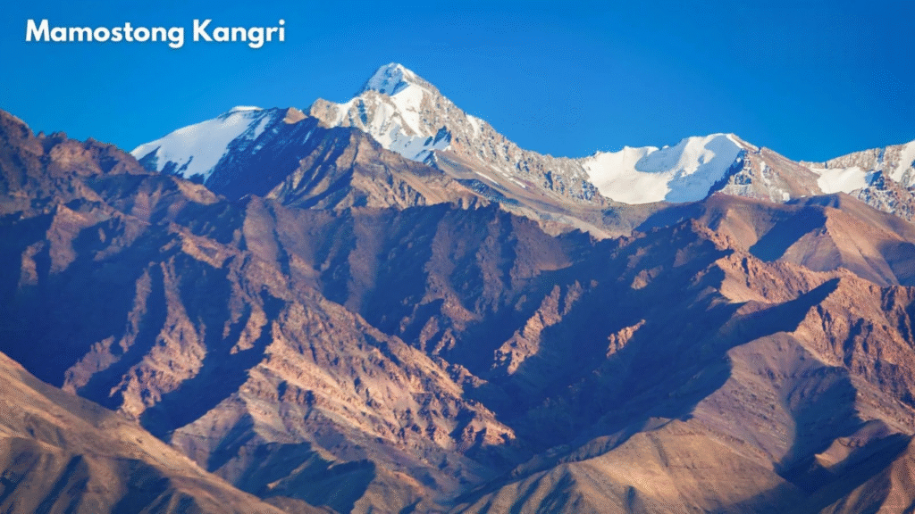
Mamostong Kangri, rising to 7,516 meters in the rugged upper regions of Ladakh, is the highest peak in the remote Rimo Muztagh, a subrange of the Karakoram range. Known as the “Mountain of Thousand Devils” in local folklore, Mamostong Kangri’s legacy is deeply entwined with history, adventure, cultural intrigue, and natural wonder.
Geographic Setting & Location
Mamostong Kangri stands at 35°08′27″N 77°34′39″E in eastern Karakoram, approximately 30 kilometres east-southeast of the Siachen Glacier. This untouched peak lies between formidable glaciers and massifs, surrounded by Chong Kumdan, Kichik Kumdan, Mamostong, and Terong glaciers. Its isolation is further reinforced by proximity to military-sensitive borders with China and Pakistan, making access extremely difficult for most climbers.
Key Details:
Notes:
- All supplies must be carried in; there are no settlement or lodge facilities.
- Commercial packages for similar Ladakh peaks range from ₹3,00,000 to ₹7,00,000 per person, including logistics, permits, support, and a guide. However, Mamostong Kangri itself rarely has organised tours due to restrictions.
- Most expeditions occur between late June and early September for more stable weather.
History and Cultural Significance
The region’s rich history is marked by ancient trade routes which connected Ladakh to Central Asia, braving perilous passes and formidable terrain. The name “Mamostong Kangri” traces to Yarkandi traders: “Mamo” means fog in Turkic, “Stong” means thousand, and “Kangri” means snow peak, evoking the perpetual mist shrouding its summit.
Folklore recounts a doomed group of traders lost forever in its foggy shadow, giving rise to local tales that imbue the mountain with mystical caution. The peak’s proximity to Saser La and the Shyok River underscores its prominence in local culture and the legendary Central Asian lifeline.
Unique Geological and Climatic Features
Mamostong Kangri is characterised by five prominent ridges, northwest, east, north, south, and southwest, each offering dramatic landforms and glacier networks. Steep rock faces, broken glaciers, and snowfields define its architecture, with deep crevasses and seracs challenging explorers.
The climate is harsh, with subzero temperatures prevailing most of the year. Climbers and trekkers must navigate avalanche risk, sudden storms, and freeze-thaw cycles. The ideal climbing period runs from late June to early September due to relatively stable weather, though unpredictability is a constant.
First Ascents and Mountaineering Legacy
Mamostong Kangri was first explored by Europeans in 1907, but remained officially unclimbed until an Indo-Japanese team achieved the summit via the northeast ridge in 1984. The summit party included N. Yamada, K. Yoshida, R. Sharma, P. Das, and H. Chauhan. Subsequent ascents have been rare, usually conducted by military teams, notable mountaineers, or scientific expeditions:
| Year | Expedition | Route | Leader |
|---|---|---|---|
| 1984 | Indo-Japanese | Northeast Ridge | Col. B.S Sandhu |
| 1988 | Indian Army (Ladakh Scouts) | East Ridge, Thangman Glacier | Anand Mohan Sethi |
| 1989 | Indian Army | East Ridge | M.P Yadav |
| 1990 | Border Security Force | East Ridge | S.C Negi |
| 1992 | Women’s Pre-Everest | East Ridge | Bachendri Pal |
| 2007 | Indian Army | East Ridge, Thangman Glacier | Col. Ashok Abbey |
| 2010 | Himalayan Club | East Ridge | P.C. Sahoo |
Trekking and Climbing Routes
Mamostong Kangri is famed among elite mountaineers for its technical demands. The standard approach generally traces the South Chong Kumdan Glacier, requiring meticulous navigation across deeply crevassed terrain and steep slopes. Expedition teams typically establish a series of camps:
- Base Camp: 4800–4920 meters, usually on Thangaman glacier.
- Higher Camps (I-III): Progressively advanced, with Camp III housing summit teams at 6600 meters.
- Summit Push: Involves rope fixing, negotiating crevassed snowfields, serac barriers, and a final summit ridge exposed to fierce winds.
No commercial expeditions operate due to the region’s remoteness and security restrictions. Climbers must be highly skilled, self-reliant, and equipped for extreme conditions.
Challenges and Restrictions
Mamostong Kangri’s vicinity to disputed borders and military zones imposes strict access limitations. Expeditions require special clearances from Indian defence authorities, making it one of perhaps the least-attempted major peaks in India. Civilian explorers rarely attempt this route, and logistics are daunting with no established base camps or settlements nearby.
Environmental Considerations
Glacial systems around Mamostong Kangri feed into strategic rivers and hydrological networks vital to Ladakh and beyond. The massif’s scientific value attracts glaciologists and climate researchers who investigate Himalayan climate change impacts and the long-term water supply for downstream populations.
Recent climbing expeditions have emphasised strict “leave no trace” policies, ensuring all waste is carried out to preserve the mountain’s pristine environment.
Nearby Peaks and Attractions
While Mamostong Kangri itself is rarely visited, the region offers other notable summits like Rimo I (7,385 m), Rimo III (7,233 m), and Aq Tash (7,016 m), each with its own cultural and geological intrigue. The nearby Siachen Glacier and Nubra Valley are key attractions for high-altitude trekkers willing to brave the elements and security procedures.
Significance for Local Communities
Though largely uninhabited, the region’s mountains and trade routes once sustained local economies and cross-border culture, helping forge Ladakh’s distinctive heritage. The mountain’s legendary reputation continues to inspire stories among Ladakhi and Turkic peoples.
Trekking Preparation and Safety
Due to the highly challenging and remote environment, a Mamostong Kangri trek or climb requires:
- Advanced mountaineering skills, glacier travel, and rope management.
- Self-sufficient provisioning and emergency preparedness.
- Acclimatisation to extreme altitudes and unpredictable weather.
- Strict environmental stewardship and waste management.
There are no nearby support facilities; teams must carry all supplies and equipment.
Climate and Weather Impact
Weather conditions are typically extreme: temperatures plunge below freezing year-round, high winds and snowstorms are common, and quick changes can create hazardous avalanche or whiteout scenarios. It’s crucial for any expedition to closely track regional forecasts and plan for sudden turnarounds.
Recent News
This autumn, a multinational team of climate scientists and Indian Army mountaineers began a landmark expedition to study the fragile glaciers of Mamostong Kangri amid record regional warming. With global interest in Himalayan environmental change, the mission highlights rising concern that changes in glacial mass, vital for local rivers, may accelerate water stress in Ladakh and beyond.
The team will also attempt to repeat historic ascent routes first pioneered in the 1980s, combining glaciological survey with technical climbing. Expedition members note a dramatic thinning of glacier walls and increased frequency of avalanches, creating a more hazardous landscape than described in previous missions. This study could yield vital data for hydrologists and policymakers facing uncertain long-term water availability in South Asia.
Local Ladakhi leaders and mountaineering authorities continue to advocate for a careful balance between scientific access and strict preservation of the region’s cultural and environmental legacy.
FAQs About Mamostong Kangri
Where is Mamostong Kangri located?
Mamostong Kangri is in the Rimo Muztagh of the eastern Karakoram range, Ladakh, India, near the Siachen Glacier.
How high is Mamostong Kangri?
The summit reaches 7,516 meters (24,659 feet), making it one of the highest mountains in India and the entire region.
Why is Mamostong Kangri rarely climbed?
Its remote placement, challenging terrain, and strict military restrictions make access very difficult, with only a handful of successful documented ascents.
What is the best time for climbing or trekking to Mamostong Kangri?
Late June to September offers the most stable weather, though conditions can still be dangerous; all expeditions require thorough preparation.
What is the cultural importance of Mamostong Kangri?
It has played a legendary role in local folklore and historic trade, symbolising natural might and connecting Ladakh to Central Asia.
Are there trekking routes for tourists?
There aren’t commercial trekking routes due to security and natural obstacles; only experienced and authorised teams have attempted climbs.
What environmental precautions are necessary?
Expeditions should adhere to “leave no trace” ethics, removing all waste and preserving untouched wilderness.