
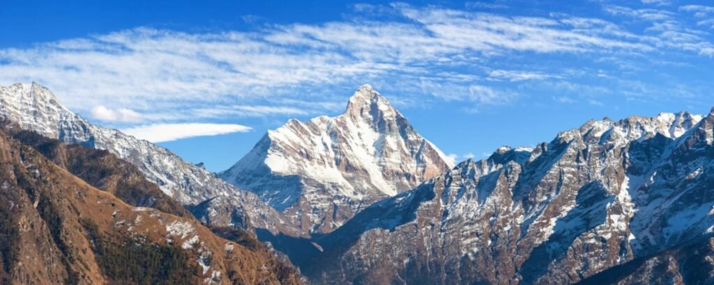
Hardeol Mountain (Hardeol), meaning “Abode of Shiva” or “Temple of God,” stands as one of the most revered and prominent peaks in the Kumaon Himalayas of Uttarakhand, India. Its towering height of 7,151 meters (23,461 feet) crowns the northeastern wall of the celebrated Nanda Devi Sanctuary, overlooking the Milam Glacier and high valleys rich in myth and natural grandeur. Recognised not only for its dramatic skyline but also for its spiritual importance and cultural legacy, Hardeol is both a challenging expedition for mountaineers and an inspiration for pilgrims and adventurers alike.
Location and Geographic Features
Hardeol is situated at the northern extremity of the Milam Valley in the Pithoragarh district of Uttarakhand. It is a crucial component of the mighty ring of peaks that shield the Nanda Devi Sanctuary, flanked by the notable summits of Trishuli to its north and Rishi Pahar to the south, all linked on a rugged north-south ridge leading to Nanda Devi East. The mountain’s geographical coordinates are approximately 30°33′36″N, 80°00′36″E.
Notable Characteristics
- Height: 7,151 meters (23,461 feet)
- Prominence: 1,244 meters (4,081 feet)
- Parent Range: Kumaon Himalayas
- Nearest Town: Munsiyari, a popular base for treks in the region
- Accessibility: The base of the mountain is best reached by trekking from Munsiyari via the Milam Glacier trail
Key Details:
Note:
- General trekking in the area (Milam Glacier, nearby valleys) can be organised at a reasonable cost, while summit attempts involve higher fees, logistics, and technical preparation.
- Climbing Hardeol is only suited for experienced mountaineers due to its remote location, technical challenge, and avalanche-dangerous slopes.
Historical and Cultural Significance
Sacred Legacy
Hardeol is deeply enshrined in local folklore and Hindu mythology, often mentioned in ancient texts as part of the sacred landscapes that house gods and spirits. The people of Johar Valley, locally known as ‘Jowar Bhotiyas,’ worship Hardeol as their guardian deity, calling it ‘Hardoli’ or ‘Hardol’. Over centuries, the peak has served both as a pilgrimage destination and a symbol of regional identity and reverence for nature’s might.
Mountaineering History
The journey to conquer Hardeol has been fraught with challenges:
- The first major attempt was made in 1939 by a Polish team, tragically resulting in two fatalities.
- The following decades saw multiple expeditions thwarted by avalanches and severe weather, including aborted missions in 1964, 1965, and 1966.
- In 1974, an Indo-New Zealand women’s team faced a devastating avalanche.
- First ascent: Achieved only in 1978 by an Indo-Tibetan Border Police team led by S. P. Mulasi. Only a handful of subsequent successful ascents have been recorded, the most notable in 1991 by the Indian Border Security Force.
Trekking Routes and Tourist Access
Approaching Hardeol
The best approach to Hardeol is from the eastern side, ascending via the Ikualari Glacier and following the Trishuli valley towards the formidable Hardeol icefall. This route is technically demanding and requires a high level of expertise in glacial travel, crevasse rescue, and steep snow and ice climbing.
How to Get There
- Road: You can reach Munsiyari by road from major towns such as Kathgodam and Almora; taxis and buses are readily available.
- Rail: The nearest railway station is Ramnagar, accessible via train from mainland India.
- Air: Pantnagar Airport is the closest airlink, roughly 188 km from Munsiyari.
Trekking Experience
Expeditions typically begin at Munsiyari, and trekkers traverse through scenic high-altitude meadows, dense forests, and the surreal ice world of the Milam Glacier. Trekking to the peak’s base offers panoramic views of neighbouring summits like Nanda Devi, Tirsuli, and Nanda Gond, alongside glimpses of unique Himalayan flora and fauna.
Climatic Influence and Terrain
The climatic and topographical features of Hardeol make it both breathtaking and hazardous:
- Severe Weather: The region is notorious for abrupt weather changes, strong winds, and heavy snowfall, even during the optimal climbing months from May to October.
- Avalanche Risk: Steep, glaciated slopes and the southeastern face in particular are highly prone to avalanches and rapidly changing snow conditions.
- Unique Landscape: Hardeol presents a dramatic mix of ice walls, chiselled ridges, and snowfields, demanding careful navigation and expert mountaineering skills.
Ecotourism, Conservation, and Local Culture
Although not as commercialised as some neighbouring peaks, Hardeol holds immense value for eco-conscious travellers:
- The surrounding region teems with biodiversity and offers opportunities to observe rare Himalayan wildlife and endemic plant species.
- Local villages, predominantly inhabited by the Johar Bhotiyas, provide a glimpse into traditional Himalayan lifestyles, spiritual rituals, and centuries-old customs linked to the mountains.
- Exploration here supports sustainable tourism and generates awareness of the fragile ecological balance in high-altitude environments.
Major Tourist Attractions Nearby
While Hardeol itself is reserved for serious mountaineers, the broader Milam Valley and Kumaon region offer a variety of destinations:
- Nanda Devi East Base Camp: Accessible via a trek sharing part of the route with Hardeol.
- Milam Glacier: A key highlight for trekkers, offering mesmerising views of Hardeol and the surrounding giants.
- Local Festivals: Traditional events and rituals dedicated to mountain deities enrich the visitor experience.
- Nearby Attractions: Betulidhar, Maheshwari Kund, Kalamuni Top, and river rafting opportunities on the Gori Ganga River.
Best Time for Treks and Climbs
The peak climbing and trekking window falls between May and June and September and October, coinciding with relatively stable weather. Monsoons bring heavy rainfall and increase landslide risks, while winters render the region inaccessible due to snow accumulation.
Recent News
With 2025 witnessing a resurgence of interest in remote Himalayan expeditions, Hardeol has appeared in the spotlight as a non-commercial, technically demanding alternative for global mountaineers. Enhanced accessibility to Munsiyari, improved local infrastructure, and a vibrant exchange between local communities and adventure seekers have fostered greater visibility for the peak, drawing accolades for sustainable tourism and high-altitude conservation efforts.
Local authorities in Uttarakhand have renewed their push for responsible eco-tourism and community-driven hospitality in the Milam Valley, inviting trekkers and climbers to experience the sacred landscape of Hardeol while championing environmental stewardship. This collaborative effort is turning Hardeol into a beacon for those seeking adventure, cultural immersion, and a profound connection with India’s mystical Himalayan frontier.
FAQs About Hardeol Mountain
Where is Hardeol Mountain located?
Hardeol lies in the Pithoragarh district of Uttarakhand, India, forming the northeastern wall of the Nanda Devi Sanctuary and guarding the Milam Valley.
What is the height of Hardeol?
Hardeol’s summit rises to 7,151 meters (23,461 feet) above sea level, making it one of the tallest peaks in Uttarakhand.
Is Hardeol suitable for beginner trekkers?
No. Hardeol is a technically challenging peak, recommended only for seasoned mountaineers with experience in high-altitude climbing and glacier navigation.
What is the historical significance of Hardeol?
Apart from being a natural fortress, Hardeol holds deep cultural and spiritual importance for local communities and is frequently mentioned in regional legends and Hindu mythology.
How can tourists reach the base camp?
Travellers can reach Munsiyari by road, rail, or air and then embark on a multi-day trek through the Milam Valley to the base of Hardeol.
What are the best months for mountaineering expeditions?
The ideal window runs from May to October, with the post-monsoon season offering more stable weather for summit attempts.
What neighbouring peaks can be seen from Hardeol?
Trishuli, Nanda Devi East, Rishi Pahar, Nanda Gond, and Tirsuli West are the immediate neighbours, offering an awe-inspiring panorama.
Are there any environmental precautions or rules for Hardeol expeditions?
Given its ecological sensitivity, strict leave-no-trace principles, minimal impact trekking, and proper waste management are mandatory for all expeditions.